Canadian National Fire Database (CNFDB)

The Canadian National Fire Database (CNFDB) is a collection of forest fire data from various sources; these data include fire locations (point data) and fire perimeters (polygon data) as provided by Canadian fire management agencies (provinces, territories, and Parks Canada). Fires of all sizes are included in the database, but only those greater than 200 hectares in final size are shown in the map above — these represent a small percentage of all fires but account for most of the area burned (usually more than 97%).
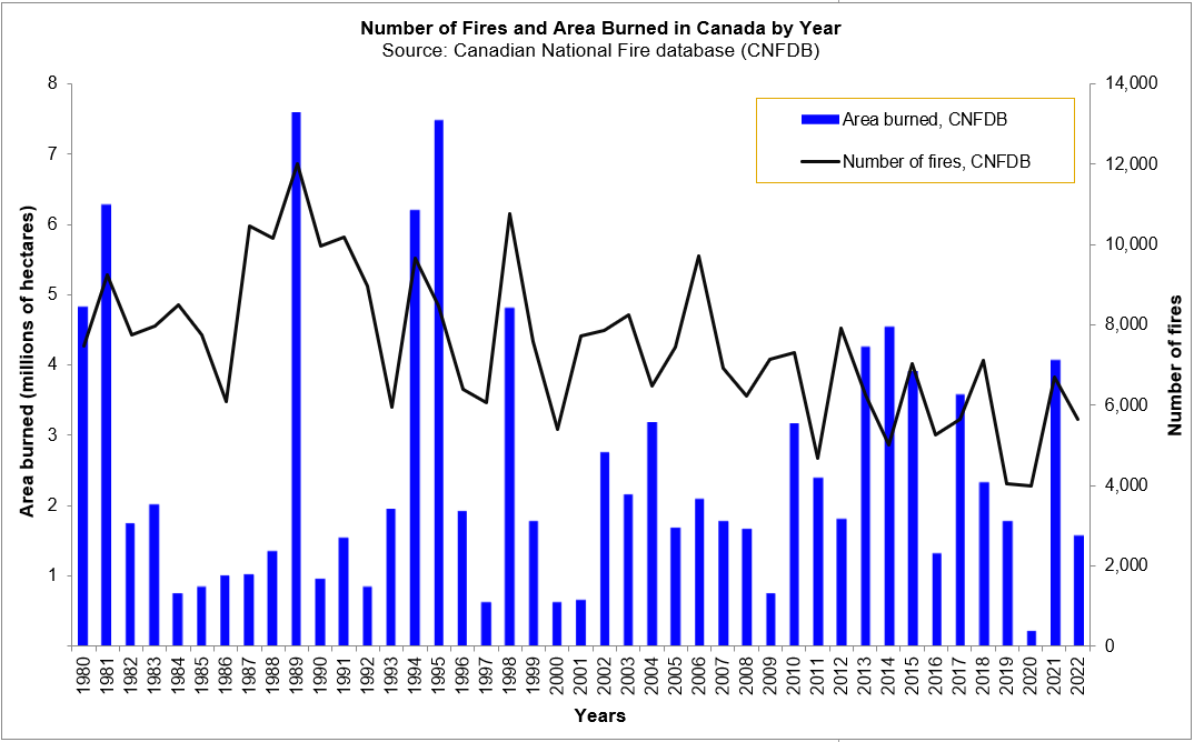
Statistics from the CNFDB

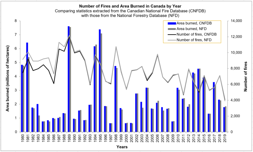
Statistics from the CNFDB compared with the NFD

The figure above shows statistics extracted from the CNFDB, and provides a comparison with those numbers reported annually to the National Forestry Database (NFD). This chart shows the high variability in both number of fires and area burned in Canada per year.
Note that the data contained in the CNFDB are not complete nor are they without error. Not all fires have been mapped, and data accuracy varies due to different mapping techniques. This collection includes only data that has been contributed by the agencies. Data completeness and quality vary among agencies and between years.
Based on data in the National Forestry Database, over 8000 fires occur each year, and burn an average of over 2.1 million hectares. Also, lightning causes about 50% of all fires but accounts for about 85% of the annual area burned. Note that such statistics derived from the CNFDB may differ due to incomplete data. More statistics are available in the National Wildland Fire Situation Report.
For analyses for a single province or territory or for Parks Canada, contact the appropriate agency. Links to the agency web sites can be found below, or can be found through the Canadian Interagency Forest Fire Centre (CIFFC).
The CNFDB is compiled and maintained by the Canadian Forest Service and includes data from the previously released Large Fire Database (LFDB). The LFDB is no longer maintained separately from the CNFDB.
For Canada-wide analyses, contact members of the Fire Research Group at the Canadian Forest Service:
- For questions about forest fire data, please contact John Little
Data from the CNFDB and the previously released LFDB can be downloaded from the CWFIS Datamart.
Acknowledgments
The database is a large collaborative effort by all Canadian fire agencies. We thank the many individuals who contributed to this effort, including fire crews, field personnel, photo interpreters, pilots, digitizers, and analysts. Compilation of the Canada-wide database was partially supported by the Canadian government programs of ENFOR (ENergy from the FORest),the Program on Energy Research and Development, the Climate Change Action Fund, and Action Plan 2000.
Thanks to the following fire management agencies for their collaboration and contributions:
- Alberta
- British Columbia
- Manitoba
- New Brunswick
- Newfoundland and Labrador
- Northwest Territories
- Nova Scotia
- Ontario
- Parks Canada
- Prince Edward Island
- Quebec - SOPFEU (Société de protection des forêts contre le feu)
- Saskatchewan
- Yukon Territory
Publications
The following papers present analyses of these data:
Hanes, C.C.; Wang, X.; Jain, P.; Parisien, M.-P.; Little, J.M.; Flannigan, M.D. 2019. Fire-regime changes in Canada over the last half century. Canadian Journal of Forest Research 49: 256-269. doi: 10.1139/cjfr-2018-0293
Burton, P.J.; Parisien, M.-A.; Hicke, J.A.; Hall, R.J.; Freeburn, J.T. 2008. Large fires as agents of ecological diversity in the North American boreal forest. International Journal of Wildland Fire 17(6): 754-767.
Parisien, M.A.; Peters, V.S; Wang, Y.; Little, J.M.; Bosch, E.M.; Stocks, B.J. 2006. Spatial patterns of forest fires in Canada 1980–1999. International Journal of Wildland Fire 15:361–374.
Stocks, B.J.; Mason, J.A.; Todd, J.B.; Bosch, E.M.; Wotton, B.M.; Amiro, B.D.; Flannigan, M.D.;Hirsch, K.G.; Logan, K.A.; Martell, D.L.; Skinner, W.R. 2003. Large forest fires in Canada, 1959–1997. Journal of Geophysical Research 108, D1: FFR5, 1-12. doi:10.1029/2001 JD000484
Amiro, B.D.; Todd, J.B.; Wotton, B.M.; Logan, K.A.; Flannigan, M.D.; Stocks, B.J.; Mason, J.A.; Martell, D.L.; Hirsch, K.G. 2001. Direct carbon emissions from Canadian forest fires, 1959 to 1999. Canadian Journal of Forest Research 31:512–525.